પુરાતત્વીય સ્થળો
Archaeological Sites near Nakhatrana
Two Harappan settlements lie inside Nakhatrana taluka, and rock-cut caves and an old fort complete a short archaeology trail across western Kutch.
Which archaeological sites are near Nakhatrana?
Four archaeological sites are near Nakhatrana. Desalpar Gunthli, 17 km away, and Khirasara are Harappan settlements of the Indus Valley civilisation inside Nakhatrana taluka. The Siyot Caves, 62 km north-west, began as a Buddhist shrine in the 2nd or 3rd century CE, and Paddhar Gadh is the site of an old fort near town.
| Place | From Nakhatrana | Area |
|---|---|---|
| Desalpar Gunthli | 17 km NW | Nakhatrana taluka |
| Khirasara | 36 km SW | Nakhatrana taluka |
| Siyot Caves | 62 km NW | Kateshwar, near Atdo, Lakhpat taluka |
| Paddhar Gadh | see map | Kutch |
Paddhar Gadh
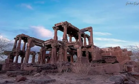
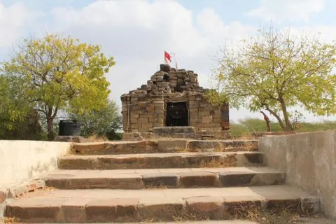
Paddhar Gadh is the site of an old fort (gadh) at Paddhar, listed in this guide among the archaeological sites within reach of Nakhatrana. Its remains are a reminder of how many small fortified seats once dotted Kutch, each guarding its villages and roads. Carved stone pillars and beams of its ruined buildings still stand, beside a small stone shrine.
- What it is
- Archaeological site
- Where
- Kutch district, Gujarat
- Distance from Nakhatrana
- Open the directions link for the route.
- By road
- By car or taxi from Nakhatrana. Open the directions link for the current route and road distance.
- Best season
- October to February, early morning; sites are open ground with little shade.
- Timings and entry
- Ruins on open ground; visit in daylight and take care on broken stone.
- Directions
- Google Maps directions from Nakhatrana
Desalpar Gunthli
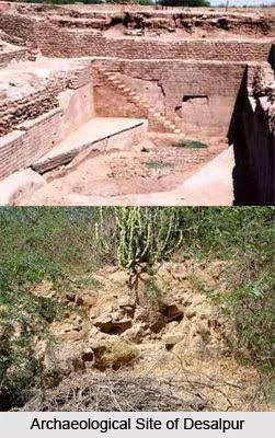
Desalpar Gunthli is an Indus Valley (Harappan) site of the 3rd millennium BCE in Nakhatrana taluka, excavated in 1963. Local accounts describe a fortification outline about 2 km round (nakhatrana.wordpress.com), making it one of the closest Harappan sites to Nakhatrana. It is 17 km north-west of Nakhatrana in a straight line.
- What it is
- Archaeological site
- Where
- Nakhatrana taluka, Kutch district, Gujarat
- Distance from Nakhatrana
- 17 km north-west in a straight line
- By road
- By car or taxi from Nakhatrana. Open the directions link for the current route and road distance.
- Best season
- October to February, early morning; sites are open ground with little shade.
- Timings and entry
- Open archaeological site with little shade; visit early in the day.
- Directions
- Google Maps directions from Nakhatrana
Khirasara
Khirasara is a mature Harappan town on the Khari river in Nakhatrana taluka, lived in from about 2600 to 2200 BCE (Wikipedia). Excavations by the Archaeological Survey of India from 2009 uncovered a fortification wall, a warehouse and houses; its seals are at the Kutch Museum. It is 36 km south-west of Nakhatrana in a straight line.
- What it is
- Archaeological site
- Where
- Nakhatrana taluka, Kutch district, Gujarat
- Distance from Nakhatrana
- 36 km south-west in a straight line
- By road
- By car or taxi from Nakhatrana. Open the directions link for the current route and road distance.
- Best season
- October to February, early morning; sites are open ground with little shade.
- Timings and entry
- Open archaeological site with little shade; visit early in the day.
- Directions
- Google Maps directions from Nakhatrana
Siyot Caves
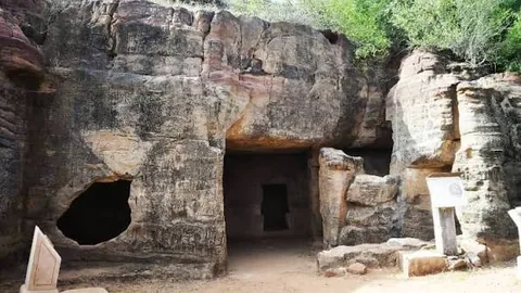
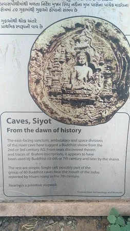
Siyot Caves are rock-cut caves near Kateshwar and Atdo in Lakhpat taluka. The state archaeology signboard at the site dates the main cave to a Buddhist shrine of the 2nd or 3rd century CE, used by Buddhists until the 6th or 7th century and later by Shaivas. It is 62 km north-west of Nakhatrana in a straight line.
- What it is
- Archaeological site
- Where
- Kateshwar, near Atdo, Lakhpat taluka, Kutch district, Gujarat
- Distance from Nakhatrana
- 62 km north-west in a straight line
- By road
- By car or taxi from Nakhatrana. Open the directions link for the current route and road distance.
- Best season
- October to February, early morning; sites are open ground with little shade.
- Timings and entry
- Protected monument; visit in daylight.
- Nearby
- Lakhpat
- Directions
- Google Maps directions from Nakhatrana
Frequently asked questions
Are there Harappan sites near Nakhatrana?
Yes, two. Desalpar Gunthli, 17 km north-north-west of town, is a Harappan site of the 3rd millennium BCE excavated in 1963. Khirasara, 36 km south-west, is a mature Harappan town of about 2600 to 2200 BCE with a fortification wall and a large warehouse. Both are in Nakhatrana taluka.
How far is Dholavira from Nakhatrana?
Dholavira, the Harappan city listed as a UNESCO World Heritage Site in 2021, is on Khadir Bet island in the Great Rann, at the far eastern side of Kutch. That is about 114 km from Nakhatrana in a straight line, measured from Wikipedia’s coordinates, and much farther by road. The Harappan sites inside Nakhatrana taluka are far closer.
What are the Siyot Caves?
The Siyot Caves are rock-cut caves near Kateshwar and Atdo in Lakhpat taluka, 62 km north-west of Nakhatrana in a straight line. The signboard at the site dates the main cave to a Buddhist shrine of the 2nd or 3rd century CE, later used by Shaivas. They fit well into a day trip to Lakhpat or Mata no Madh.
Can you visit the Harappan sites near Nakhatrana?
The Harappan sites near Nakhatrana are mostly open ground where the excavated outlines of walls and buildings survive, rather than museums with guides and signboards. Seals from Khirasara are on show at the Kutch Museum in Bhuj. Go with a local guide if you can, wear a hat and carry water, because there is little shade.
When is the best time to visit archaeological sites in Kutch?
October to February is the best time, ideally early in the morning. The sites are open ground with almost no shade, and temperatures from March to June can pass 40°C. Low winter sun also shows wall lines and mounds more clearly. After the monsoon, tracks to remote sites can be muddy for a few weeks.