કચ્છ
Kutch
Kutch, officially Kachchh, is India’s largest district: 45,674 square kilometres of salt desert, grassland, hills and coast in western Gujarat, with Bhuj as its headquarters. This page explains the district and where Nakhatrana fits into it.
Key takeaways
- Kutch is India’s largest district by area, at 45,674 km².
- The rulers of Kutch first governed from Lakhiarviro, near Nakhatrana (1147–1548), then from Bhuj.
- The Great Rann, the Banni grasslands, the Gulf of Kutch and the Arabian Sea shape the district.
- Nakhatrana is the headquarters of one of its ten talukas and the base for western Kutch.
What is Kutch?
Kutch, officially Kachchh, is a district in western Gujarat, India, and the largest district in the country at 45,674 square kilometres. It had 2,092,371 people at the 2011 Census, and its headquarters is Bhuj. The Rann of Kutch borders it to the north and east, and the Gulf of Kutch and Arabian Sea to the south and west.
Kutch is almost an island: salt marsh on one side, sea on the other. Its people speak Kutchi as well as Gujarati, and its crafts, music and food are distinct from the rest of Gujarat (Wikipedia).
What are the main regions of Kutch?
Kutch has five broad landscapes. The Great Rann of Kutch, a seasonal salt marsh, covers the north; the Little Rann lies to the east; the Banni grasslands fringe the Great Rann; a belt of low hills, including 458-metre Kala Dungar, runs through the middle; and the Gulf of Kutch and Arabian Sea coast run along the south and west.
- Great Rann of Kutch
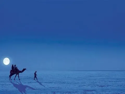
- A seasonal salt marsh that dries into the white Rann in winter; visitors see it at Dhordo.
- Banni grasslands
- Grassland and wetland on the edge of the Great Rann, home to Maldhari herders; see Banni Grassland Reserve and Chhari Dhand.
- Hills of central Kutch
- Low ranges including Kala Dungar, the highest point at 458 m, and Dhinodhar Hill near Nakhatrana.
- Coast
- The Gulf of Kutch and the Arabian Sea, with ports and beaches such as Mandvi Beach.
- Little Rann of Kutch
- A second salt marsh on the eastern side of the district, beyond the scope of this western Kutch guide.
What are the talukas of Kutch?
Kutch district has ten talukas: Abdasa, Anjar, Bhachau, Bhuj, Gandhidham, Lakhpat, Mandvi, Mundra, Nakhatrana and Rapar. Nakhatrana, Abdasa and Lakhpat make up most of western Kutch, where the majority of places in this guide are found. Bhuj taluka contains the district headquarters, and Mandvi taluka holds the best-known beach in Kutch.
| Taluka | Places to see |
|---|---|
| Nakhatrana | Dhinodhar Hill, Desalpar Gunthli, Khirasara |
| Abdasa | Tera Jain Tirth, Suthari Jain Tirth, Pingleshwar Beach |
| Lakhpat | Mata no Madh, Narayan Sarovar, Koteshwar Mahadev, Lakhpat, Siyot Caves, Guneri Mangroves |
| Mandvi | Mandvi Beach, Vijay Vilas Palace, Shyamji Krishna Varma Memorial, Ambedham |
| Bhuj | District headquarters, with the airport and railway station. Aina Mahal, Prag Mahal, Swaminarayan Temple, Bhuj (Kutch) Museum, Smriti Van Museum, the Chhatardi royal cenotaphs, Kalo Dungar, the Road to Heaven, and the craft villages of Sumarasar, Ajrakhpur and Bhujodi with the Living and Learning Design Centre (LLDC) |
| Anjar | Jesal Toral Samadhi, MacMurdo’s Bungalow, Ajepal’s monastery |
| Bhachau | Mogal Dham at Kabrau, Khadir Bet and Dholavira, the UNESCO-listed Harappan city |
| Gandhidham | Adipur, Kandla port, Tuna |
| Mundra | Desalpar Kanthi, Bhadreshwar |
| Rapar | Little (Small) Rann of Kutch, Kanmer excavation site |
What is the history of Kutch?
Kutch was home to the Harappan civilisation, whose city of Dholavira is now a UNESCO World Heritage Site. From 1147 the Cutch State was ruled first from Lakhiarviro, near present-day Nakhatrana, and from 1549 from Bhuj. Kutch joined India after independence in 1947, and has been part of Gujarat since the state was formed in 1960.
| When | What happened |
|---|---|
| 3rd millennium BCE | Harappan settlements, including Dholavira and, in Nakhatrana taluka, Desalpar Gunthli and Khirasara |
| 1147–1548 | Rulers of Kutch govern from Lakhiarviro, near present-day Nakhatrana |
| 1549 | The capital moves to Bhuj |
| 1762 | An army from Sindh defeats Kutch at Zara (Jara) |
| 1819 | An earthquake hits Kutch; Lakhpat declines as a port |
| 1947–1948 | Kutch joins India; the princely Cutch State ends |
| 1960 | Kutch becomes part of the new state of Gujarat |
| 26 January 2001 | The Gujarat earthquake devastates Kutch; Bhachau and Bhuj are among the worst hit |
| 2021 | Dholavira is inscribed as a UNESCO World Heritage Site |
Sources: Wikipedia: Cutch State, Wikipedia: Kutch district, Wikipedia: Dholavira.
How is western Kutch different from eastern Kutch?
Western Kutch, around Nakhatrana, Abdasa and Lakhpat, is the land of the old Jadeja estates, the far-western shrines of Narayan Sarovar and Koteshwar, Harappan sites like Desalpar and quiet beaches. Eastern Kutch, around Bhachau and Rapar, holds Dholavira and the Little Rann. Dholavira is about 114 km from Nakhatrana in a straight line.
Most first-time visitors split Kutch into two bases: Nakhatrana for the west and the white Rann, and a separate trip east for Dholavira. See every place in western Kutch, measured from Nakhatrana.
Where does Nakhatrana fit in Kutch?
Nakhatrana is the headquarters of Nakhatrana taluka, 42 km west-north-west of Bhuj in a straight line, on the main road to the far west. It sits where central Kutch meets western Kutch, which is why it works as a base: the white Rann, the far-western shrines, the Abdasa coast and Mandvi are all within a day’s drive.
Bhuj is the district capital and the gateway, with the airport and railway station. Nakhatrana is the next step west. Read about Nakhatrana, or see how to get there.
Frequently asked questions
Is it Kutch or Kachchh?
Both are correct. Kachchh is the official spelling used by the Government of Gujarat and in the census, while Kutch is the most common spelling in English and in tourism, and older records use Cutch. All three refer to the same district in western Gujarat. This guide uses Kutch, and mentions Kachchh where official names matter.
Why is Kutch famous?
Kutch is famous for the white Rann, the vast salt desert that hosts the Rann Utsav festival every winter; for Dholavira, a Harappan city listed by UNESCO; for crafts such as embroidery, Rogan painting, bell-metal and block printing; and for its distinct Kutchi language, music and food. It is also India’s largest district.
What is the headquarters of Kutch district?
Bhuj is the headquarters of Kutch district. It has been the capital of Kutch since 1549, when the rulers moved there from Lakhiarviro, near present-day Nakhatrana. Bhuj has the district’s main airport and railway station, which makes it the gateway for most visitors. Nakhatrana is 42 km west-north-west of Bhuj in a straight line.
How many talukas are in Kutch?
Kutch district has ten talukas: Abdasa, Anjar, Bhachau, Bhuj, Gandhidham, Lakhpat, Mandvi, Mundra, Nakhatrana and Rapar. Each taluka has its own headquarters town. Nakhatrana, Abdasa and Lakhpat together cover most of western Kutch, which is the focus of this guide and where most of its places are found.
How big is Kutch district?
Kutch covers 45,674 square kilometres, making it the largest district in India by area. Much of that area is the Great Rann, a seasonal salt marsh, so population density is low: the 2011 Census counted 2,092,371 people. Distances are long, so travellers usually choose a base, such as Nakhatrana for the west.
What is the highest point in Kutch?
Kala Dungar, the Black Hill, is the highest point in Kutch at 458 metres, in the north of the district near the edge of the Great Rann. Closer to Nakhatrana, Dhinodhar Hill rises to 361 metres and is crossed at its southern tip by the Tropic of Cancer, which makes it a popular climb from the town.